THEN AND NOW THROUGH THE LENS: THE EVOLUTION OF A CITY
Vancouver is young in comparison to most cities in the world. Not having been incorporated until 1886, many of the worlds’ great cities had voluminous histories by that time. Yet since settlement began in the northwest, urbanization has been quite rapid. As a persistent top-three winner in numerous worldwide reports on the most livable cities, one can see why Vancouver’s population has been climbing steeply. Vancouver’s outward expansion and inner density have snowballed over the past century in so that the façade of the city has been changing non-stop. The continual evolution of the city often makes earlier images of it unrecognizable. In addition to meeting the demands of higher density living, difficulties preserving and cherishing the city’s limited heritage infrastructure are a few amongst many contributing reasons for frequent changes to Vancouver’s appearance. Oftentimes it is only the permanence of the North Shore Mountains towering watch over the city, a specific coastline, or domineering ancient tree that visually links an old and new image of the cityscape.
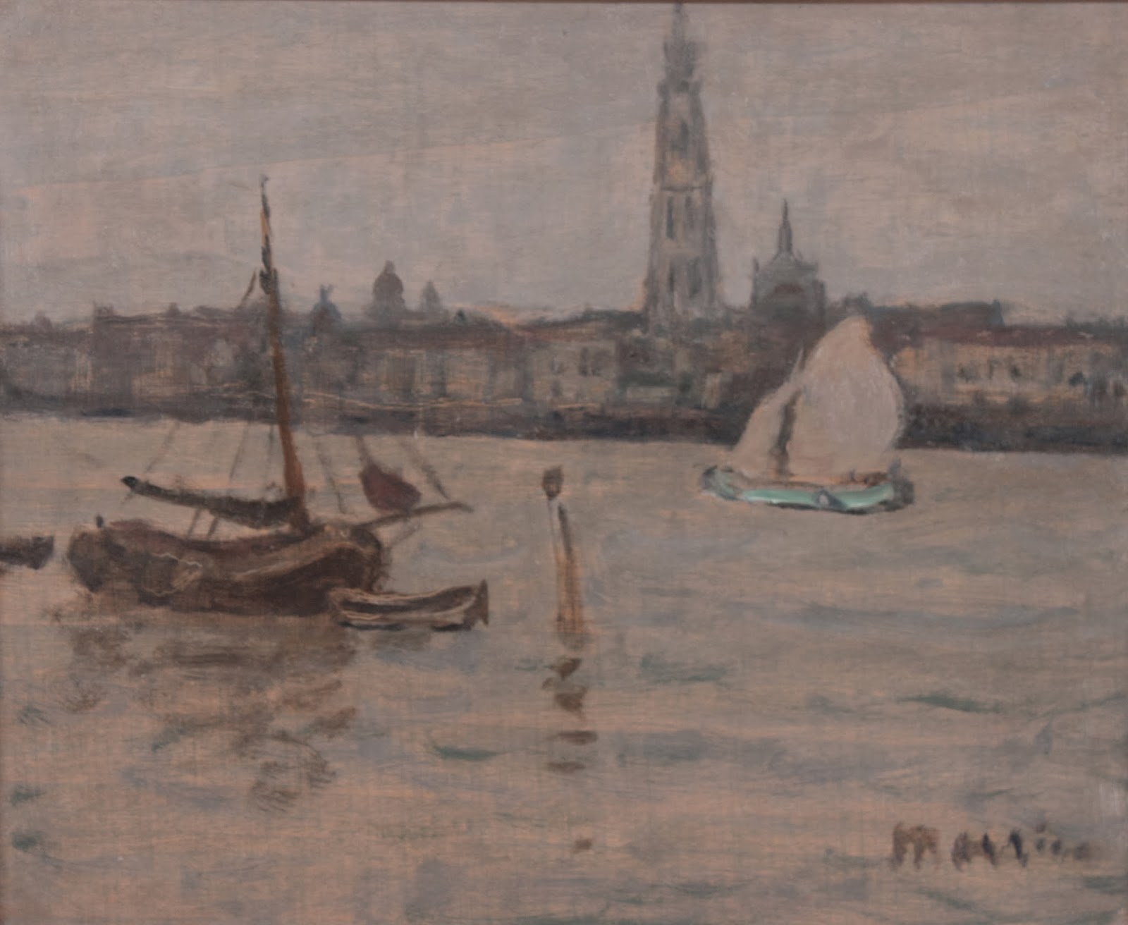
I thought a light-hearted blog comparing views of some of the historical photographs from our exhibition Bygone BC with some of my own contemporary snapshots of the same place might make for a trivial but thought-provoking contrast and comparison. I would argue that with the exception of the domineering geography of the city there will be more contrasts than comparisons. This is particularly curious considering I have often found myself in research being able to match the urban imagery in paintings 100 years or older with the near identical contemporary view of the same city, particularly in Europe. Two good examples are Canadian painter James Morrice’s View of Paris from the Left Bank (circa 1905) and his View of Antwerp (1906).


In both these examples, if the buildings were different there would not be any other marker to indicate location. In Vancouver an old and new photograph might yield a drastically different city skyline or set of buildings, but the location might still be recognizable by the very distinct topography of the city (one can recognize a mountain peak, a specific peninsula or coastline shape). Such is the case with a watercolour painted at Stanley Park looking out to Point Atkinson on the North Shore in 1889 by Frederic Marlett Bell-Smith. I went to Stanley Park and found the exact same viewpoint, and found it satisfying. This is what gave me the idea to select historical photographs from Bygone BC and present the contemporary equivalents.


Moving eastwards by barely a kilometre from where Bell-Smith painted in Stanley Park, photographer Frank Gowen took this photograph of English Bay circa 1917-18. The shoreline of English Bay is discernable but the entire infrastructure is different. The pier has vanished, as has an entire side of Beach Avenue that was once occupied with residences and small business. This is completely gone, and is replaced by the biking and walking seawall path and park. The only things in the photo still present are the Sylvia Hotel and the Alexandra Park bandstand (roof visible lower right)


Moving further east and north into the downtown core takes us to our next photography location. Now the iconic Hotel Vancouver, in the late 19th and early 20th century this would have been one of the highest points at which to photograph a panorama of the city. It was a popular location for photographers such as Richard Henry Trueman, William Notman and the Bailey Brothers and many more. All these photographers made several versions of views from the CPR Hotels. I of course cannot get onto the roof of the current Hotel Vancouver, but I took a picture from the nearby car park roof to note how time has passed and the once tall hotel is dwarfed amongst high rises. Perhaps even if I had reached the windows on the upper floor I might not get the panoramic view I was looking for. Instead I might have shot a reflection of myself in the windows of the next-door skyscraper.


Perhaps the most striking contrast of ‘then and now’ that I could procure is two photographs of Thurlow Street. The earlier photograph was taken by the Bailey Bros. in 1882, and depicts oxen hauling logs within a surprisingly dense forest (not far from where the Marine Building was to be erected). The second photograph is my contemporary snapshot at the corner of Thurlow and West Hastings with the now old Marine Building in the background. In just one hundred years this location has gone from forested with tall cedars and Douglas firs to forested with skyscrapers.


I will finish my then and now tour of Vancouver through historical and contemporary photographs by returning full circle to Stanley Park. This comparison is taken at Brockton Point looking back onto Coal Harbour and the city behind. The early photograph was taken by Frank Gowen in 1917-1918 and was included as part of a photograph album of thirty views of the city. The second is of course my own contemporary shot, taken circa 4:30 pm on December 5th, 2013. I particularly enjoy the old and new marine gas station in the harbour.


I hope this lighthearted blog has been of interest to Vancouverites and non-Vancouverites as well. Please enjoy the urban scenes in this December’s exhibition Bygone BC: Historical Photographs of Urbanization in British Columbia.

BY: JILL TURNER
PHOTO CREDITS:
1. and 3. James Morrice View of Paris and View of Antwerp (Previously sold at Masters Gallery Ltd.)
2. amd 4. Screen shots of the Left Bank of the River Seine in Paris and Antwerp looking across to the Cathedral of Our Lady
5. Frederic Marlett Bell-Smith Stanley Park looking across to Point Atkinson and Bowen Island Beyond watercolour, 1889 (Masters Gallery Ltd. Vancouver)
6. Snapshot from Stanley Park Looking across to Point Atkinson and Bowen Island Beyond, taken by Jill Turner December 2013
7. Frank Gowen, English Bay circa 1917-1918, photograph in Bygone BC as part of an album of 30 views of Vancouver and the Rocky Mountains
8. and 9. Snapshot of English Bay with the Alexandra Park Bandstand and English Bay Beach, taken by Jill Turner December 2013
10. Anonymous, View of Vancouver Looking North silver gelatin print, circa 1898, photograph in Bygone BC
11. and 12. Snapshots of the Hotel Vancouver Roof blocked off and View of the top of the Hotel Vancouver and other downtown buildings surrounding it, taken by Jill Turner December 2013
13. After Bailey Brothers. Oxen Hauling Logs, Thurlow Street, 1882 vintage copy print on board of the original photograph, photograph in Bygone BC
14. Snapshot of Thurlow St. and W. Hastings with the Marine Building in the background, taken by Jill Turner December 2013
15. Frank Gowen The Waterfront, Vancouver circa 1917-1918, photograph in Bygone BC as part of an album of 30 views of Vancouver and the Rocky Mountains
16. Snapshot of the waterfront at Coal Harbour from Brockton Point, Stanley Park, taken by Jill Turner December 2013
No comments:
Post a Comment